|
January 11, 2015
Kangaroo Island, South Australia
35�47S 137�46.5E
We sit in the pilot house on this gray blowy Sunday afternoon, pinned against the rusty town pier in American River, Kangaroo Island, waiting for the winds to shift to the west. Tourists on the dock are taking pictures of Onora.
Carol, the volunteer radio operator, arranged our permission to tie up here after her forecast for a period of high winds meant this would be the only safe place for us to wait it out. She has also warned us that the next challenge on this five-hundred mile trip will be the �Backdoor Passage' between KI and the mainland- a nasty mix of wind against the current that is sure to test our stomachs.
On Wednesday, after nine months, we finally said our goodbyes to Port Lincoln and made promises to our many friends to return someday. This was the longest Onora has stayed anywhere since being launched in Auckland ten and a half years ago, it was beginning to feel like home and leaving felt more like moving out of town than sailing off.
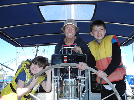
Some time ago our son Justin, wife Jill, Max (8) and Hazel (5), suggested visiting us in Australia. We convinced them that Port Lincoln, with its sheltered islands for sailing, lightly visited beaches and our local friends for guidance, was the unlikely ideal destination.
After thirty long traveling hours and four flights they landed two days after Christmas wondering if it was worth the effort. The next day we visited a family animal park featuring kangaroos, koalas and camels where the owner, who we had met at a Christmas party, recruited Max to help feed the critters and Hazel fell in love with a baby guinea pig that she could hold and pet. At the end of the first day Max exclaimed that if every day would be as good this would be the best vacation ever. It was for us and when they got on the plane to leave last week, they agreed it was a great vacation and understood our attraction to this place.
January 16, 2015
Melbourne, Australia
37�49S 144�55E
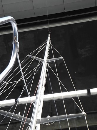
We are just two hundred meters from our reserved spot at Docklands City Marina, just the other side under the Bolte Bridge which is listed on our chart as being 25 meters high but the marina insists it is closer to 30. As a precaution we are tied against a 'strictly forbidden' pier waiting for the tide to drop to low before proceeding. Our mast is 25.4 and an inch can make a big difference.
We arrived here from Kangaroo Island in two overnight hops. Both featured strong winds but from the right direction. We left at first light Monday morning under a low sky in grey blowy drizzle and soon entered the Back Door Passage where winds and seas squeeze between KI and the mainland. A frequent chop makes it unpopular with Aussies and now us.
Once through, the seas continued to be lumpy and occasionally washed over the pilot house adding drama to the experience of getting slammed around. We were happy to arrive in Portland thirty-six hours later.
Carol at American River was impressed commenting that only racing boats with large crews make the trip as fast, but a big crew isn't necessary when going downwind and at 25-30 knot you will get there in a hurry.
Portland to Melbourne was a shorter trip, carried the same 'high wind warnings', all down wind, but had the added feature of requiring timing to arrive during slack water at the mouth, aka "The Rip", of the huge Port Phillip Bay on which Melbourne sits some thirty miles to the north. This leg packed higher winds to 35 knots but kinder seas making it a better experience.
I had figured that "slack water" meant being at the Rip at high tide. It wasn't, however we passed through without much fuss.
Next I worried that all of the wind blowing from the south might push enough water up north to make a difference going under the bridge. I questioned the marina and which referred me to the Coast Guard which referred me to the port authority which referred me to the bridge authority which referred me back to the port authority. Meanwhile the estimated bridge clearance dropped with each call starting with the marina at 29.2 to a final of 25.0 for a whopping total of 4.2 meters. It must be sinking.
The bridge guy took pity and offered to discuss this with the port people and call back. A few minutes later he called saying they did not want to make a statement but, when pressed, offered that the wind might push enough water to make a foot of difference. The good news is that there is an atmospheric high pressure which I figure will offset this. The bridge person thinks we should make it but suggested that we take it on an angle so, if we did hit it, the boat might tip on its beam. Before ringing off , he added that if we made contact we were obligated to report it.
It is now 7:20 and time to go see how high it really is....To be continued.
Made it without a scratch. You can bank on it that this bridge is more than 25.4 meters at .30 above datum but I have no idea by how much.
[ Click here for Pt. II ]
|